
 Facebook
 Twitter
 LINE
LINE
One of the most well-known natural environments of the Gaomei area is the Gaomei Wetlands, which have gained widespread popularity in recent years. However, before delving into an introduction of the Gaomei Wetlands, it is important to first understand what a wetland is.
A wetland refers to land that is permanently or intermittently inundated with water, situated between terrestrial and aquatic environments. Due to prolonged water saturation, the soil in wetlands fosters the growth of unique plant and animal species that differ significantly from those found in upland areas. Research has shown that wetlands are among the most productive ecosystems on Earth in terms of primary productivity per unit area—comparable to tropical rainforests. Their abundant water supply allows them to support a wide variety of life forms.
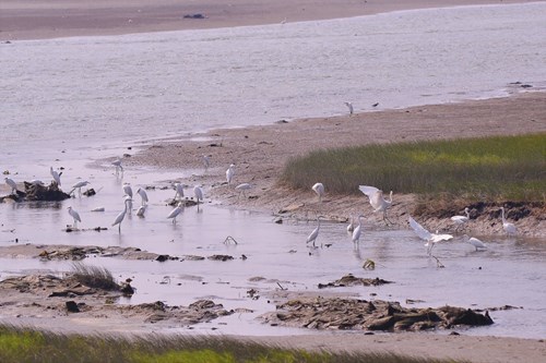
In addition, wetlands also serve as vital stopover habitats for many migratory bird species during their long-distance journeys. Moreover, one of the most remarkable ecological functions of wetlands is their natural purification capacity. International studies have indicated that one hectare of wetland possesses water purification capacity equivalent to a wastewater treatment facility with an annual operating cost of NT$4 million.
However, wetlands were historically regarded by humans as unproductive land, and many wetlands were developed into industrial zones in efforts to expand terrestrial space at the expense of coastal environments.
Wetlands can be broadly categorized into two types based on their location: freshwater wetlands and coastal wetlands. Unlike freshwater wetlands, coastal wetlands play a role in stabilizing coastlines. One of the distinguishing features of coastal wetlands is their exposure to tidal fluctuations, which influence both the duration and extent of water coverage over time. Tides are the result of the gravitational pull exerted by the moon and the sun on the Earth's oceans, causing the sea level to rise and fall periodically. During the new moon and full moon phases, the sun and moon align along the same axis, resulting in a combined gravitational force that causes the highest tidal ranges—this phenomenon is referred to as a spring tide. Conversely, during the first and third quarter moon phases, the sun and moon form a right angle relative to the Earth. At these times, their gravitational forces partially counteract each other, producing a smaller tidal range known as a neap tide.

Due to the influence of lunar phases as previously mentioned, there are typically two spring tides and two neap tides each month. On a daily basis, the tide generally rises and falls twice, with a tidal cycle lasting approximately 12 hours and 25 minutes. Additionally, the timing of high and low tides shifts by about 50 minutes later each day, a phenomenon resulting from the interplay between the Earth's rotation and the Moon’s orbit around the Earth. The area that is submerged during high tide and exposed during low tide is known as the intertidal zone. Organisms that inhabit this zone—such as fiddler crabs—have adapted over time to the cyclical nature of tidal fluctuations. As a result, many have evolved fascinating behaviors.

The Gaomei Wetlands, located at the estuary of Dajia River, were formed as a result of sediment accumulation from coastal drift. Today, they are recognized as one of Taiwan’s most distinctive coastal marsh wetlands. The vast expanses of Bolboschoenus planiculmis thriving within the wetlands serve as the most representative and iconic aquatic plant species of the area. The primary factor contributing to the formation of the Gaomei Wetlands was the construction of the Taichung Port’s northern sediment barrier. In 1932, the area was originally known as the Gaomei Seaside Resort and served as the only recreational coastal destination for residents of the Qingshui region at the time. However, following the completion and opening of Taichung Port in 1976, the area was designated as a drifting sand control zone, leading to the closure of the seaside resort. The jetty effect caused by the port’s northern sediment barrier significantly accelerated the formation of the Gaomei Wetlands.
The Gaomei Wetlands are located along the coast of central Taiwan, at the estuary of Dajia River. This region falls within the subtropical monsoon climate zone, characterized by hot, rainy summers and dry, chilly winters due to the influence of the northeast monsoon. Annual rainfall is primarily concentrated between June and August, in line with the seasonal monsoon patterns. Situated on the southern bank of Dajia River, the wetlands are rich in sand deposits and are adjacent to the river mouth, resulting in a diverse and well-structured food chain. This makes the area a vital stopover site for migratory birds and an important habitat for avian species. The Gaomei Wetlands encompass a diverse array of habitat types, including marshlands, sandy areas, mudflats, gravel beds, tidal creeks, and subtidal zones. This ecological diversity enables the wetlands to support a wide variety of life forms. As a result, compared to other wetland ecosystems, the Gaomei Wetlands exhibit an especially high level of biodiversity.

※ Source: Chiu, Wen-Yen (1999). “Ecological Education of Wetland Environments in Taiwan.” (邱文彥,(1999),「台灣濕地環境的生態教育」)Environmental Education Quarterly, No. 39, May 1999, pp. 23–32.